
- This event has passed.
TEULADA – Countryside camis Railway via Cemetery – Tue
Tue 30 September, 2025 @ 09:00 – 10:10
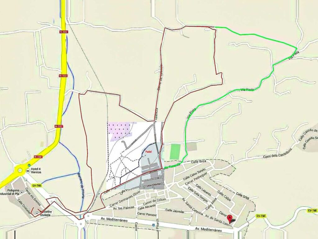
| Meeting Point | Teulada Poligono car park. GPS: 38°43’42.4″N 0°05’37.3″E | ||
| Walking Route | Distance : 5,4 km | Camis and paths railway station and cemetery | |
| Terrain | Walking Surface | Mostly tarmac roads. section of 400m dirt/stones and 150m woods path. Route goes under the railway once. Proper walking shoes required ! | |
| Ascent | Medium hill out of Teulada. Mostly flat. | ||
| Directions to Meeting Point | From Teulada-Moraira: Drive to the bottom of the main dual carriageway. At the first roundabout you take the SECOND exit (the first one takes you back into Teulada or the railway station), and it is at the next roundabout you take the FIRST exit and under the railway. At the next roundabout, turn left, then sharp right into the car park (watch out for cars leaving the car park!). From Gata/Benissa: Take N332 until you reach the roundabout outside Teulada. Turn to Teulada and at the next roundabout, turn right, then sharp right into the car park (watch out for cars leaving the car park!). Park close-by in front of the ecopark entrance. | ||
Walk Description
There are very few road signs. Where possible, They are referenced in the description to help you coordinate with the map.
- Walk to the Teulada end of the car park, turn left and go down to the nearest pedestrian crossing. Cross and take the road opposite and immediately turn right.
- Follow the road as it sweeps left. When the tarmac ends, walk straight on. The station is very close and visible to your right.
Choice 1: The Rural Route - Your path angles slightly away from the station and becomes a wide dirt track. There are fields all around. Just after the track bends left. Continue the track until you reach a T-junction with a wider road.
- Turn right at the T-junction. Walk about 50m to the small building at your right on the corner. Turn right here.
- Continue on this road, under the railway, until you reach a T-junction. Turn right and follow the road until you reach the carrer de Valencia.
- Go to step 10.
Choice 2: The Urban Route in case of wet weather - Walk to the Teulada end of the car park, turn left and go down to the nearest pedestrian crossing. Cross and take the side-walk opposite and follow this around the roundabouts to the railway station.
- Walk past the station approx 450m along Calle de Tenerife (EW) uphill to the crossroad and turn left(before the football stadium).
- Go to step 10.
Common Route - Turn left onto carrer de Valencia, ignoring side roads and tracks, until the road bends to the right. Follow the road now till the end of the tarmac. The road splits in 2 dirt tracks.
Option 1 (5,9km) (Green track on the map) - Take the left dirt track. Follow this track until you pass the buildings on your right. From here you have about 50m of stones and boulders to wade your way through, after that you find again a one person walking trail passing left around the big tree.
- Follow the trail which goes through bushes, until you pass a house on your right about 50m away from the trail. Continue about 50m, Do not curve to the right here, but continue straight ahead. The trail becomes wider now and is a 2m wide path through the woods. Continue this path, keep to the left on any forking, going via the edge of the wood until you reach a bigger
tarmac road. Turn right here and follow the road which joins the Via Pista and turn right here. - Follow the Via Pista road now for x km. You pass the cemetery on the left and then the football station on the right. At the corner turn right into calle Tenerife (which slopes down to the railway station).
Take the first road on the right onto Carrer de Valencia. Ignore the first road on the right and take the first track on the left past the Padel grounds (Blue track on the map). Follow this track, ignoring all tracks on the right. The track eventually turns to the left and reaches Calle Tenerife. Turn right here. - At the bottom of the hill, pass the railway station, turn right at the corner and follow the pavement around the round-a-bouts. At the next junction with the service road on the right, go left across the pedestrian crossing to reach the carpark.
- There is a bar (El Poligono) just past Llofra and next to the Toyota dealer.
Option 2 (5,4km) (Red track on the map at green split from option 1) - Take the right dirt track. Go right around the bend, you pass 2 buildings on your left. From here you have a straight dirt track for 150m which crosses the gaspipeline and continue for about 150m.
- After that the track bends left and immediately right. Another left right curving 70m further on. After 70m the road turns right and continues for about 700m. Here you reach the carrer de Valencia, turn right onto Carrer de Valencia and take the first track on the left past the Padel grounds (Blue track on the map). Follow this track, ignoring all tracks on the right. The track eventually turns to the left and reaches Calle Tenerife. Turn right here.
- At the bottom of the hill, pass the railway station, turn right at the corner and follow the pavement around the round-a-bouts. At the next junction with the service road on the right, go left across the pedestrian crossing to reach the carpark.
- There is a bar (El Poligono) just past Llofra and next to the Toyota dealer.