
- This event has passed.
JAVEA – Rafalets to Las Laderas -Tue
Tue 16 December, 2025 @ 10:00 – 11:00
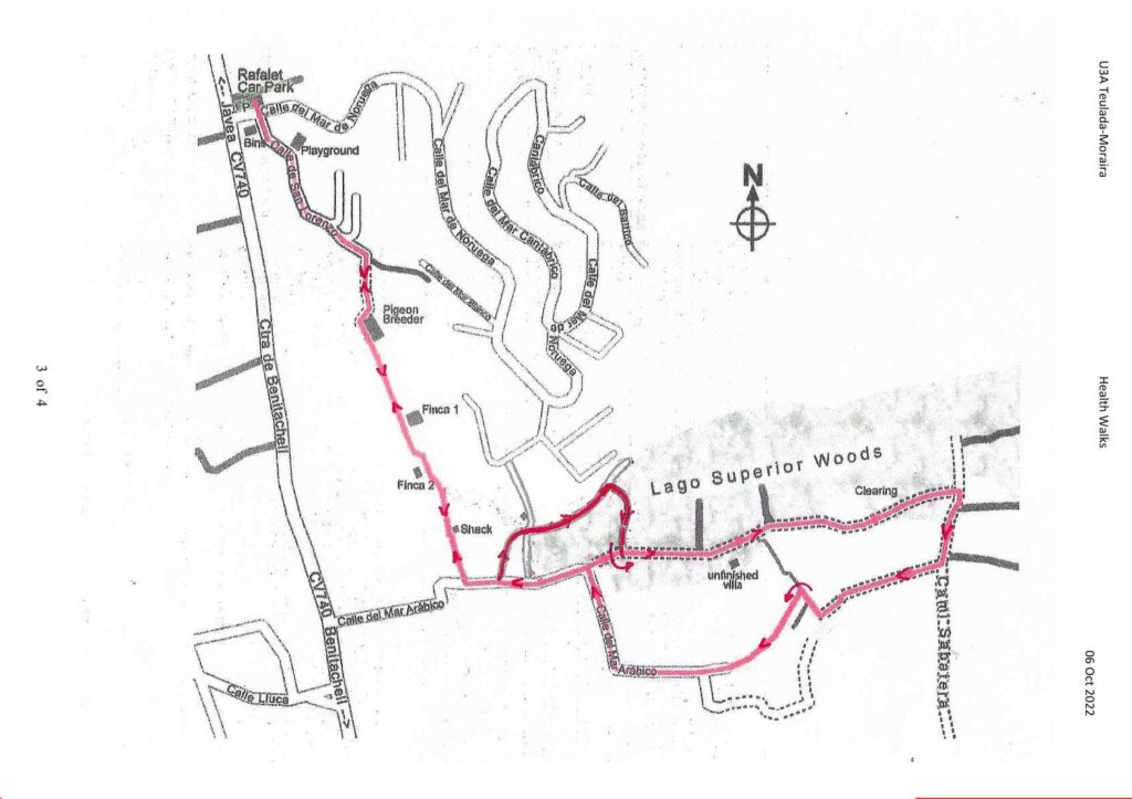
| Meeting Point | Entrance area to Rafalet urbanisation Benitachell road CV740. GPS: 38°45’44.9″N, 0°08’55.4″E | ||
| Walking Route | Distance : 4,5 km | Across to the La Colina area and around the woods and country lanes. | |
| Terrain | Walking Surface | Single dirt paths, wide stoney tracks and some quiet tarmac roads. | |
| Ascent | One small hill at the beginning. | ||
| Directions to Meeting Point | From Moraira: Take the road from to Benitachell . Turn right at the traffic lights and drive to Javea(CV740). Continue on this road passing the golf course and then a garden centre, both on the right. Approximately 200 meters pass the garden centre turn right into Rafalet on the corner of Calle del mar de Noruega. From Javea: Leave Jávea on the CV734 towards Gata. Turn left at the Ferrobox/El Paso roundabout onto CV740 to Benitachell. Go straight over the next roundabout and after approximately 800 meters turn left into Rafalet on the corner of Calle del mar de Noruega. | ||
- From the parking area cross the Rafalet entrance road and take the tarmac road passing the bin area on your right. Take the Calle de San Lorenzo road pass the picnic and playground area on the left. The road starts to climb and narrow as the surroundings become more rural.
- The tarmac road bends sharply to the left but you should keep to the right and after approximately 300 meters the tarmac road ends. At this point you will see a house on your right and a pigeon/chicken farm on your left. Go straight ahead, take the narrow track adjacent to the farm fence and walk towards the open countryside.
- Continue on the single track passing a ruined finca on your left and another on the right. A short distance ahead you will see a small concrete building. Continue straight on until you reach the road.
- This is Calle del Mar Arabigo. Turn left here along the road and just before you reach the wooded area (there is a pylon on the left), turn left up a wide track that then bends right uphill. This track meets a wide track at right angles – go straight across.
- The track narrows, quite steeply uphill. Continue up the hill until you reach a path on the right. Take this sharp right turn downhill until it reaches a wide track where you turn left.
- You are now on Carrer del Lago Superior, a wide stony track through the woods. Continue on this path for about ¾ km during which you will pass a derelict villa on the right opposite a clearing and a second clearing on the left.
- Stay on the track until you reach a crossroads and a red fire hydrant, turn right and go down the slight hill. As you clear the wooded area ignore initial tracks to the left and right and take the track with a meter high stone wall on its left.
- Follow this track towards a house, as the track reaches the house then it turns sharp right and goes downhill. After a short distance take the second single path on the left into a wooded area and continue walking along this track until you reach a small number of houses. At this point the track becomes a tarmac road.
- Continue down on this road (Calle del mar Arabigo) and at the bottom of the hill stay on the tarmac road as it bends to the right and heads towards a large house on the left. Turn left at the house and remain on the tarmac road.
- Walk down the road until you reach the track you walked earlier, and turning right along it re trace your route back to the start