
- This event has passed.
BENISSA – Cemetery SENIJA COUNTRY LANES (Thur)
March 5 @ 10:00 – 11:00
Walk leaders: Keith & Val
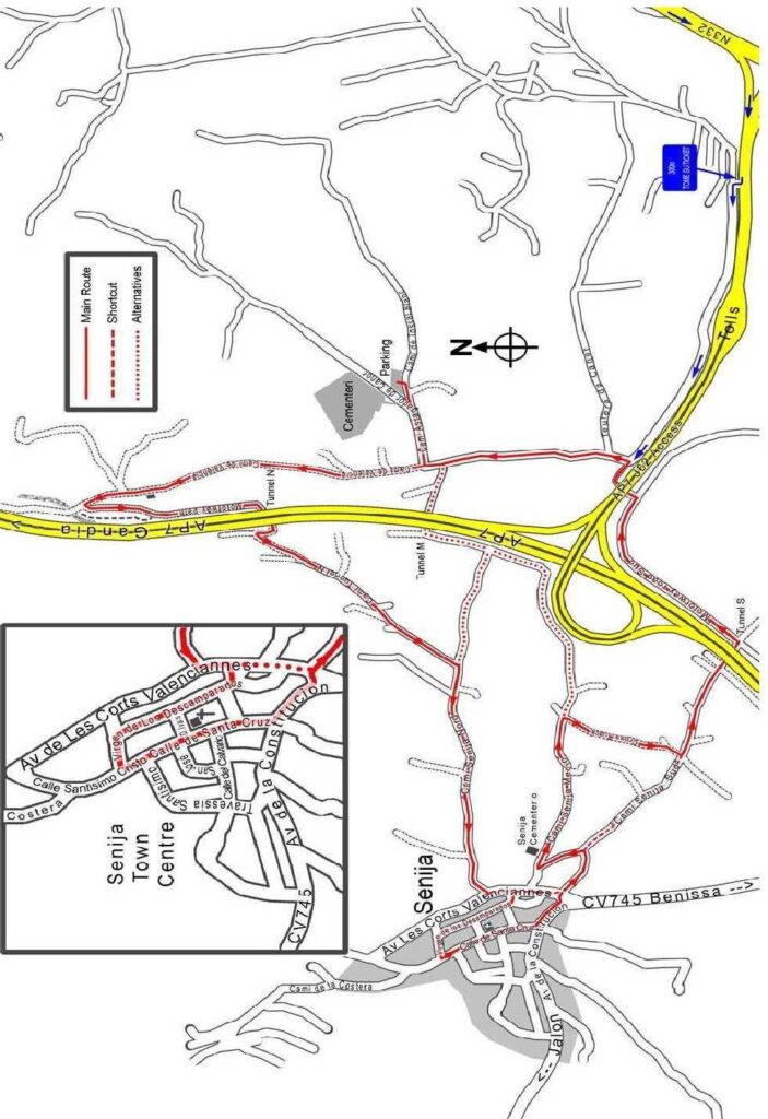
| Meeting Point | Carpark in front of the Benissa cemetery close to the A7 entrance gate. Use View Venue Website below for precise location. What3words: referrals.debility.skinfold | ||
| Walking Route | Distance: 4 km | Around the country lanes between Benissa and Senija, through orchards of olives , Almonds, oranges and vineyards. | |
| Terrain | Walking surface | Mostly well made surfaces (tarmac) road, through the fields. | |
| Ascent | 30m ascent over 2km | ||
| Directions to Meeting Point | Coming from Teulada, take the N332 towards Benissa. About 1km after the Benissa (Pedrera) trading estate take the slip road signposted for Benissa (Nort) and AP7. When you reach the roundabout take the first (almost immediate) exit for the cementeri. THE ROADWORKS IN THE FOLLOWING AREA ARE NOT COMPLETE SO THE DIRECTIONS MAY CHANGE: After about 200m turn left (signposted cementeri). Follow this road and turn left just after the communal bins area. Continue along this road until the next junction (with a traffic island), turn right and follow the signs to the cementeri, turning right into the road “Assagador de Canor”. Park at the cementeri car park. | ||
Walk Description
- Walk back towards the motorway along Assagador de Canor and turn right at the T-junction into the rougher Cami de Valencia. Follow this road parallel with the motorway.
- You will pass a green electricity building on your left and shortly afterwards you should turn sharp left onto a gravel track (the “motorway path” on the map). Soon this becomes a dirt track but it is wide enough for a car. It runs parallel to the AP7 and very close to it.
- When you reach Tunnel N, turn right and walk through the short tunnel under the AP7. When you emerge at the other end, turn right and then sharp left to join (soon) a tarmac road (which I labeled as “Cami Tunnel N” on the map). Walk through this pleasant area to the T-junction.
- Turn right onto “Cami Senija Nord” (my name) and walk up hill towards Senija. There are fields on either side. When you reach Senija (last stretch is steep), turn left into Av de Les Corts Valenciannes. Walk on to a triangular opening on the right. You now have a choice!
Full walk – through Senija Town Centre - Turn right and enter the town. Then turn right again into Calle Virgen de los Desamparados.
- Walk to the end and turn left and then left again. Walk down Calle Santisimso Cristo which soon becomes Calle de Santa Cruz. Continue to the end and turn left onto the main road (CV745).
- Approx 100m on, turn left again back onto Av de Les Corts Valenciannes. Goto step 9 Walk down “Cami Senija Sud” and very soon you reach a junction. Here you have a choice!.
- Shortcut – Avoid town centre, continue on Av de Les Corts Valenciannes and just before you reach
the main road (CV745), turn left into “Cami Senija Sud” (unsigned – my name).
Both Choices. - Walk down “Cami Senija Sud” and very soon you reach a junction. Here you have a choice!
Full Walk - Turn sharp left walk until you reach a T-junction with “Cami Senija Medio” (my name). Turn right and walk past Senija Cementeri. After passing a water treatment plant on the right, there is a wide concrete track on the right opposite a finca. Turn down this track (called “Cross Track” on the map).
- This track leads back to “Cami Senija Sud”. Turn left onto “Cami Senija Sud”. Goto step 13 Both choices.
- Shortcut – Bear right and continue down “Cami Senija Sud” until you reach the Tunnel S.
Both Choices. - Walk to the motorway and through Tunnel S. On the other side, turn left and walk along “Motorway road Sud”. Follow it around a wide sweeping curve and then turn left to go under the AP7 Access road. This will lead you back to the junction with a traffic island. Turn left and walk along until you reach the right hand turn back to the cementeri and the car park.