
- This event has passed.
BENITACHELL – Cumbre Del Sol: Around the Granadella National Park (Tue)
February 10 @ 10:00 – 11:10
Walk leaders: Jan & Ian
| Duration | Full: 1 hr 25. (6 kms) / Avoid Deep Gorge: 1 hr 10. (5.2 kms) What3words: puddles.thinking.plinth | ||
| Meeting Point | Cumbre Del Sol calle Dalias behind the Information Centre (Benitachell side). Use View Venue Website below for precise location. What3words: compress.seaside.gecko | ||
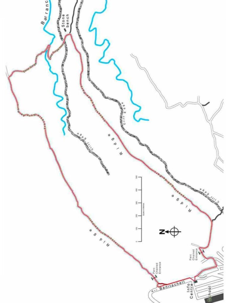
| Walking Route | Distance : 5 km | full 6 km / short 5,2 km | |
| Terrain | Walking Surface | Some rough gravel tracks. Major hills are concrete roads. | |
| Ascent | Two major hills to descend and ascend. | ||
| Directions to Meeting Point | From Moraira: Turn right at Benitachell traffic lights. At the next traffic lights turn right up the hill to Cumbre. From Jávea: Go to Benitachell and turn left at traffic lights after Mas y Mas. Follow road up the long hill. After the sharp right hand bend at the top, go down the hill, past the information centre on the right, U-turn and pass the other information centre and immediately turn sharp right into the side road behind the centre. Park here. | ||
Walk Description
- Walk up the slight hill away from the cars.
- At the end of this road, turn left and then left again.
- After 20 metres, take the track to the right. Go under/over/around the chained entrance to the Park. 50 metres down this track, it turns sharply to the right.
- The track is concreted as it bends to descend the hill. Eventually it will become a better gravel path.
- Follow this track “Travesia Sud de Parc” for about 2 kilometres enjoying the views. There are no paths or tracks joining your route on this section. There is a deep valley to your right.
- Eventually the track reaches a viewing point that overlooks Granadella playa to the front and right (although you cannot see the actual beach). There is even a stone bench here.
- The track turns sharp left at this point and then becomes a concrete road just before it descends steeply to the barranca below.
- At this stage you have a choice.
Choice 1 (to avoid the main hills) - The path ahead is very steep down to the barranc and then back up again, followed by a steep ascent later on. If you don’t want to do this, then you can turn around and retrace your footsteps back to the car. The views on the return include those awful terraces of apartments near the top of Cumbre, so you might need dark sunglasses.
- You will have to climb the steep hill back to the Park entrance. When you reach a T-junction with a tarmac road, turn left, then right and right again to return to the Info Centre.
Choice 2 ( Full walk) - To continue on, descend to the bottom of the (normally dry) barranc via “Deep Gorge Cami”. The concrete surface has small stones scattered about so care is needed.
- Turn sharp left to continue on up the “Deep Gorge Cami” concrete road back up the other side. This is a very
steep descent and ascent, but taken slowly (10 mins total), it is not difficult. - Once you have regained the altitude you lost on the descent, the road changes back into a track. Follow it until it joins another track at a T-junction.
- Follow the “Travesia Nord de Parc” track across a level area before it starts another ascent up a long steep concrete hill (well mostly concrete, but the higher parts are rough and rocky!).
- This will level out and lead you across a picturesque part of the park with views to the sea on your left and to
Montgo on your right. - Eventually the track will lead to another chained entrance as you leave the Park and reach a parking area.
Just before the main road (~20 metres) there is a dirt path to the left that cuts the corner and emerges onto the main road [If you cannot find the path then continue straight on]. - When you reach the main road, turn left and walk down the slight hill back to the Info Centre on the right.